| |
 |
|
|
| Format |
Folded map |
| Catalogue No. |
MCR 0224 |
| Scale |
1:35,000 |
| Language |
Bilingual |
| Price |
$10.75 |
| |
 |
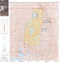
Published by Natural Resources Canada, 1990.
Description: |
This map is one of a series of maps published
for the Parks Canada Centennial (1985). This bilingual map shows general
reference data for the general area. The map was based on large-scale Alberta
topographic maps; their topographic data is shown in metric form (with a
contour interval of 10 metres). Shaded relief is used on the map. The map
contains data of particular interest to park visitors such as detail about
trails and campgrounds. Data are current to the mid 1980s.
|
|
Mount Revelstoke and Glacier
National Parks |
 |
|
|
| Format |
Folded map |
| Catalogue No. |
MCR 0219 |
| Scale |
1:70,000 |
| Language |
Bilingual |
| Price |
$10.75 |
| |
 |
Published by Natural Resources Canada, 1987.
Description: |
This map is one of a series of maps published
for the Parks Canada Centennial (1985). This large, bilingual map refers to two
national parks in southern British Columbia. The map shows general reference
data such as roads, railways and drainage, with a particular focus on glacial
features. All parts of the map area contain topographic data (with the contour
interval being 100 metres). Many peaks are named, and often have their
elevations shown (with data in metres). Shaded relief is used on the map. The
map contains data of particular interest to park visitors such as detail about
trails and more names in popular parts of the parks. Data are probably current
to the early 1980s.
|
|
Pacific Rim National
Park |
 |
|
|
| Format |
Folded map |
| Catalogue No. |
MCR 0223 |
| Scale |
1:70,000 |
| Language |
Bilingual |
| Price |
$10.75 |
| |
 |
Published by Natural Resources Canada, 1989.
Description: |
This map is part of a series of maps published
in the 1980's by Environment Canada, each showing one or more national parks.
The map was produced by Surveys and Mapping Branch of Energy, Mines and
Resources [now Natural Resources Canada.] The map consists of four maps. One is
a reference map to the park, at a scale of 1: 500 000, showing the three parts
of the park. The other three maps, which are all at 1: 70 000, show each of the
park's parts. The maps at 1: 70 000 were compiled from topographic maps.
However, these maps have some features not found on a normal topographic maps,
notably, shaded relief, bathymetric details, and the use of red labels to
indicate recreational features in the park. The map also has information about
the park, and contains some photos of the park.
|
|
Prince Albert National
Park |
 |
|
|
| Format |
Folded map |
| Catalogue No. |
MCR 0210 |
| Scale |
1:70,000 |
| Language |
Bilingual |
| Price |
$10.75 |
| |
 |
Published by Natural Resources Canada, 1973.
Description: |
This is the latest version of a map of this
park, first produced in 1931. The map was produced using topographic maps, and
therefore contains reference materials such as roads, railways, populated
places, and drainage. The map also shows features of specific interest to park
visitors such as campsites and places of interest. The map contains contour
lines (with a 50 foot contour interval), and also shaded relief. Data is
current to about 1970.
|
|
Waterton Lakes National
Park |
 |
|
|
| Format |
Folded map |
| Catalogue No. |
MCR 0222 |
| Scale |
1:50,000 |
| Language |
Bilingual |
| Price |
$10.75 |
| |
 |
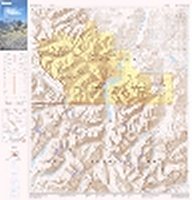
Published by Natural Resources Canada, 1988.
Description: |
This map is one of a series of maps published
for the Parks Canada Centennial (1985). This large, bilingual map shows general
reference data for the general area, notably showing glacial features. The
coverage area includes a large part of adjacent Glacier National Park found in
the United States. All parts of the map area contain topographic data (with the
contour interval being 200 metres). Many peaks are named, and often have their
elevations shown (with data in metres). Shaded relief is used on the map. The
map contains data of particular interest to park visitors such as detail about
trails and more names in popular parts of the parks. Data are probably current
to the early 1980s.
|
|
|
|