| |
Baptiste Lake
 |
Map of Baptiste Lake with bathymetry
(depth).
Published by Federal Publications Inc., 2010.
Size: 20"
x 32"
Scale: 1:20 000
Format: Poster
Catalogue No:
BAPTISTE-FP
Price: $24.95
 |
Cecebe Lake
 |
Wallmap of Cecebe Lake with bathymetry
(depth).
Published by Federal Publications Inc., 2010.
Size:
16.5" x 31.5"
Scale: 1:15 000
Format: Poster
Catalogue No:
CECEBE-FP
Price: $24.95
|
Chandos Lake
 |
Wallmap of Chandos Lake with bathymetry
(depth).
Published by Federal Publications Inc., 2010.
Size: 22"
x 29"
Scale: 1:15 000
Format: Poster
Catalogue No:
CHANDOS-FP
Price: $24.95
|
Eugenia Lake
 |
Wallmap of Eugenia Lake with bathymetry
(depth).
Published by Federal Publications Inc., 2010.
Size: 21"
x 27"
Scale: 1:10 000
Format: Poster
Catalogue No:
EUGENIA-FP
Price: $24.95
|
Harris Lake
 |
Map of Harris Lake (Magnetawan District) with
bathymetry (depth).
Published by Federal Publications Inc.,
2010.
Size: 19" x 25.5"
Scale: 1:10 000
Format:
Poster
Catalogue No: HARRIS-FP
Price: $24.95
|
Kashagawigamog Lake
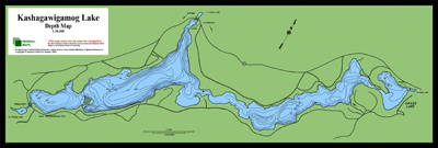 |
Map of Kashagawigamog Lake with bathymetry
(depth).
Published by Federal Publications Inc., 2010.
Size:
11.5" x 32"
Scale: 1:20 000
Format: Poster
Catalogue No:
KASHAGAW-FP
Price: $24.95
|
|
|